
Please choose the quadrangle you would like to view. Files are in Adobe Portable Document Format (PDF), and you must have the free Adobe Acrobat Reader installed on your system to view them.
Preface:
The purpose of this set of maps is to provide an up-to-date source showing the locations of Mercury surface feature names approved by the International Astronomical Union (IAU). As new names are approved by the IAU, they will be added to the maps. If a name is dropped, it will be removed, and if a feature is renamed, the new name will replace the old name. Whenever there is a change to the Mercury portion of the Gazetteer of Planetary Nomenclature, that change will be shown on the corresponding map. Changes to the gazetteer listings are also recorded in the "News" section on the title page of the gazetteer.
Image Base:
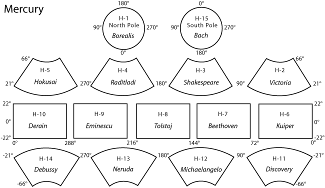
The 1:5 million-scale series of Mercury maps divides Mercury into 15 quadrangles, H-1 through H-15 (five Mercator, eight Lambert Conformal, and two Polar Stereographic quadrangles). The base mosaic was produced with orbital images by the MESSENGER Team and released by NASA’s Planetary Data System on March 8, 2013. This new global mosaic includes 100% coverage of Mercury’s surface.
Name Placement and Font:
Placement of names on the maps follows USGS cartographic standards. Names are placed inside craters if they fit comfortably within the feature. If a name does not fit inside the feature, the next preferable location is used: just outside the feature and to the right of it. If another name or another feature precludes this positioning, the name is placed elsewhere outside the feature in a readable spot. For every name that is placed outside of a crater, a dot is placed in the center of the crater so there is no question which crater the name is associated with. For non-crater features, names are placed alongside or on the features.
Acknowledgements:
Ryan Raub, Scott Akins and Mark Bailen of the USGS designed the original Gazetteer website. As of 2020, Astrogeology Software Team is responsible for website maintenance and technical updates. Bonnie Redding, also of the USGS, provided image processing and cartographic skills. We thank the MESSENGER Team for supplying the global mosaic used for the base images for this atlas. The members of the IAU’s Working Group for Planetary System Nomenclature and its Task Groups have worked since the early 1970s to provide a clear system of planetary nomenclature that represents cultures and countries from all regions of Earth. This work was funded by the National Aeronautics and Space Administration, through the Planetary Geology and Geophysics Program.
Feedback:
Please send comments regarding these maps, or planetary nomenclature in general, to Tenielle Gaither at tgaither@usgs.gov.
Sources:
Atlases:
Davies, M.E., S.E. Dwornik, D.E. Gault, and R.G. Strom, Atlas of Mercury, NASA SP-423, 1978.
Maps:
Shaded relief maps of Mercury, 1:5,000,000 series, U.S. Geological Survey, 1976 and 1977.
Shaded Relief Map of Mercury, 1:15,000,000, U.S. Geological Survey I-1149, 1979.
References:
Arizona State University, Space Exploration Resources, Mercury Gazetteer.